|
| |
|
Updated Information
|
Date |
Camp Site or Accommodation |
GPS |
Distance Today:
0km |
Meals
Marrakech market food |
Weather |
|
Near Marrakeck, Morocco |
30 January, 2004 |
Campground |
31°43.202’N 7°59.036’W |
Odometer:
3453km |
Sunny & 70 (F) degrees |
|
We’re enjoying the food and relaxation in
Marrakech so much we decided to stay another day. A final trip to the
supermarket and more repacking of the cars… |
|
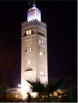
Kaoutoubia Mosque, Marrakech |
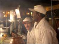
Chef at Djemaa al-Fna, the
central market |
|
Updated Information
|
Date |
Camp Site or Accommodation |
GPS |
Distance Today:
178km |
Meals
Fajitas |
Weather |
|
Near Amerzgane, Morocco |
31 January, 2004 |
Bush Camp |
31°43.202’N 7°59.036’W |
Odometer:
3631km |
Sunny & 70 (F) degrees |
|
We departed Marrakech this morning (after yet
another trip to the supermarket to resuppy our gin) and after navigating
our way out of the city we headed toward a piste recommended by the
Frederick in camp. Tomorrow is the festival of Eid al Kabir, which
involves the sacrificing of sheep. There was a lot of traffic on the road,
much of it people heading home for the celebration. Many vehicles had
sheep on them destined for tomorrow’s dinner. We crossed over
Tizi-n-Tichka pass (2260m), and after waiting for a minor bus accident to
clear, we turned off on a side road toward Telouet. After 20km the
pavement ended and we continued along a dirt road, passing many villages.
After about 30km the sun was setting and we decided to make camp where we
were rather than continuing on to the promised campground at the end of
the route. We pulled off onto a desolate plateau below the ruin of a
Berber fort and made dinner. We were concerned that locals would bother us
(asking for money, payment to camp, etc) and in fact one man made the 500
meter trek from the road out to the campsite. He said hello in Arabic and
asked (in French) for a bottle of water. We gave him one and he smiled and
walked off. I think the water was a pretense for coming to look at our
camp. He didn’t say much and was very polite, shaking all our hands (as is
the custom) before departing. We ate our dinner, cleaned up, and went to
bed under a clear sky with a bright moon. |
A Moroccan street sign. We’re pretty sure this means, “Tap your brakes twice, then keep moving.” (read right to left in Arabic, of course).
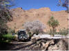
A village and terraced farmland along the piste. Our "bushcamp." The wall of the ruin can be seen at the top of the hill.
.")
A Moroccan street sign. We’re pretty sure this means, “Tap your brakes twice, then keep moving.” (read right to left in Arabic, of course).
|
|
Updated Information
|
Date |
Camp Site or Accommodation |
GPS |
Distance Today:
75km |
Meals
Chicken Marsala (ala Connie) |
Weather |
|
Zagora, Morocco |
01 February 2004 |
Camping Sindaibad |
30°19.589’N 5°50.067’W |
Odometer:
3851km |
Sunny & 75 (F) degrees |
|
After a cold clear night, we awoke to yet
another sunny day. Witt took a short hike up the hill to the ruins while
Graham made coffee. After packing up camp, we continued on our way at
about 930am. We passed through several villages with the children running
after the cars asking for sweets, pens, or anything they could think of.
This behavior is the unfortunate result of previous travelers’ generosity.
Difficult though it was, we did not give anything out. By 1130 we were on
pavement again and set out for Zagora along a highway that runs vaguely
through the vallee du draa. The landscape is incredibly barren, with
rock-strewn hills and sparse vegitation. There is striking evidence of
geological uplifting, with vast curved rock ledges running across the
hills. The villages we passed through on the main road were at first
eerily empty of people. Then later in the day, we saw people standing at
the side of the road talking. Inevitably they were dressed very well, with
men in long white or brown robes and the women in amazing colorful
garments that contrasted with the surrounding reddish brown soil and
buildings. We arrived at our destination in Zagora at about 430 and easily
found the campsite recommended by lonely planet. |
Making our way along the piste fording the river (again) A village along the piste

Making our way along the piste
|
|
Updated Information
|
Date |
Camp Site or Accommodations |
GPS |
Distance Today:
147 km |
Meals
Stir Fry |
Weather |
|
Near Mhamid, Morocco |
02 February 2004 |
Campground |
29°53.645’N 6°11.845’W |
Odometer:
3998 km |
Sunny and 75 (F)
degrees
|
|
With the symphony of barking
dogs, braying donkeys, a catfight and the obligatory 6am call to prayer,
none of us got much sleep last night. We awoke and went to get our tire
repaired in what seems to be a ritual we perform every few days. Once that
was done and after a little shopping and some petit dejeuner in Zagora we
topped off our tanks and headed for Mhamid and the start of our second
piste. Zagora is (or was) apparently traditional stop on the route to
Tombocktu, for there is a sign in town which claim it takes 52 days to
reach that desert oasis from Zagora by camel. The town also seems to be a
tourist hub for those seeking camel, 4x4, or ATV trips into the desert. We
arrived in Mhamid just before lunch. We were unable to stop in town to
discuss our route without being accosted by tour guides (driving Land
Rover 110s) offering their services. Apparently the widespread use of GPS
by independent travelers has hurt their business. Unable to convince them
that we did not desire their services, we turned to our own GPS and made
for the first waypoint. As soon as we were far enough from town, we
stopped for a lunch which was hastened by swarming flies. This reminded me
very much of Alice Springs, Australia. Another guide came by on a
motorbike from the opposite direction. He was less insistent and chatted
with us for awhile. After I declined his generous offer of 50 camels for
my Land Rover, he rode off. The first 10km on the piste were sandy, then
the terrain became more rocky as Chris Scott (the author of our guide
book) promised. At one point we had to adjust course cross-country as the
track we were following was veering too far to the south and too close to
the Algerian border (only about 30km away). Gotta love that GPS. We
re-gained the piste and followed it for about 50 km before making camp
amongst some small dunes. Shortly after starting dinner preparations, a
camel herder walked into our camp from the desert. Dressed in a tattered
robe and headscarf, he certainly looked the part. His face was dark,
weathered, and leathery and he spoke no French. We offered him a cup of
tea, sweetened with an obscene amount of sugar as it is traditionally
served here. He sat down and we attempted to communicate using sign
language and our Moroccan Arabic phrase book. We gave him a cigarette,
which he smoked, and then got up to leave. We all shook hands, then he
walked up the crest of a dune, his headscarf blowing in the wind, and
disappeared back into the desert. We finished our dinner and washed up,
then spent a little time star gazing and strolling about in the sand by
the light of the nearly full moon. I climbed to the top of a dune and
could see for miles. There were no artificial lights to be seen, nor did
we see or hear a single aircraft overhead. |
Jen trying on a headscarf in Zagora. Graham in berber regailia Only 52 days by camel to tombouctou Our campsite in the dunes Our visitor heading to wherever he was going

Jen trying on a headscarf in Zagora.
|
|
Updated Information
|
Date |
Camp Site or Accommodations |
GPS |
Distance Today:
225km |
Meals
Pasta with packet sauce |
Weather |
|
Tata, Morocco |
03 February 2004 |
Municipal Camping |
29°44.828’N 7°58.425’W |
Odometer:
4223 km |
Cloudy & 80 (F) degrees
|
|
It was so quiet last night
that we could actually hear the hum of our refrigerator from inside the
tent (the fridge is pretty quiet). We got a very peaceful night’s sleep
and awoke to another sunny day in the desert. After making coffee and
museli for breakfast, Jen and I went off to climb a nearby sand dune. We
broke camp and started driving at about 10am. We saw many camel herder’s
camps, with the children running sometimes hundreds of meters over stony
ground to ask for “un stylo” or “un bonbon.” It becomes very tiresome, but
at the same time it’s understandable give how little these people have
compared to us. We stopped at a police checkpoint and chatted with the
officer there. He told us he’d been stationed there for a year and a half
and we were the first Americans he had met on the piste. He said that he
didn’t see much in the way of fresh fruit or girls out there, so we gave
him some cookies and a few oranges. We couldn’t help in the “girls”
department, as we hadn’t brought any extras along. We pulled off into some
dunes for a rather gritty lunch. Another couple of hours and we arrived
back on the tarmac near Foum Zguid. We drove a further 120km to Tata,
where we sandwiched ourselves in with a bunch of European retirees in RVs.
Morocco seems to be the Arizona of Europe, except that “Campground” seems
in most cases to mean a walled in parking lot. |
|
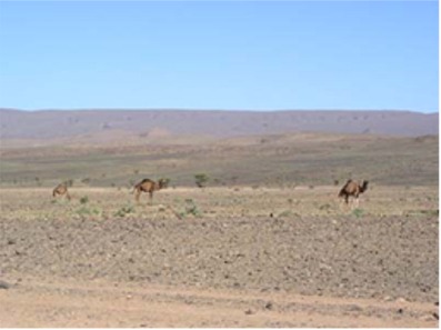
Camels grazing along the piste |
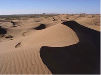
More sand dunes... |
|
Updated Information
|
Date |
Camp Site or Accommodations |
GPS |
Distance Today:
175km |
Meals
Tagines at a local restaurant |
Weather |
|
Tafraoute, Morocco |
04 February 2004 |
Bush Camping |
29°43.347’N 8°58.908’W |
Odometer:
4398 km |
Sunny & 65 (F) degrees
|
|
We left the campground at Tata
this morning at about 10am and started another piste from Chris Scott’s
book. They’ve paved some of the route, which cut off some time, but we
still had about 50 km of dirt track. The pavement ended in a village (Souk-Tleta-de-Tagmoute)
and the track wound through town for what seemed like forever. We drove up
a river valley full of palm trees and amazingly green grass. There were
several villages and lots of people, and in marked contrast to the last
piste, the people were very friendly, saying “bon jour” and “bon voyage”
and only a few of the children asked for handouts. At one point a few kids
jumped onto the back of our truck and went for a ride. They thought it
quite funny when Connie climbed on with them. We climbed up 3500 feet on a
switch-backing trail then wound across a plateau before regaining the
tarmac. 80km later we were in Tafraoute. The town seems quiet and fairly
low-key with few touts to hassle and loads of European retirees in RVs.
The one campground in town, like in Tata, is a walled compound with RVs
parked as in a parking lot. Just outside the campground is a large area of
much more inviting bush camping. There are probably twice as many RVs out
here as are in the campground. There is great opportunity here for someone
to buy some land and put in a proper campground. We walked into town for
an excellent Moroccan meal consisting of a traditional soup, a tagine
dish, and dessert with sliced oranges topped with a bit of honey and
cinnamon. |
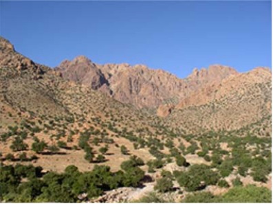
The mountain & desert oasis along the piste. Local kids riding on the back of our quatre-quatre (4x4). Driving along the piste. (Note the swirling geologic features) Fantastic scenery near Tafraute.

|
|
Updated Information
|
Date |
Camp Site or Accommodations |
GPS |
Distance Today:
107km |
Meals
Pizza at local pizzaria |
Weather |
|
Tiznit, Morocco |
05 February 2004 |
Municipal Campsite |
29°41.664’N 9°43.548’W |
Odometer:
4505 km |
Sunny & 75 (F) degrees
|
|
This was day 20 on the road
since leaving Downton England! So, we woke in Tafraute surrounded by
fantastic scenery. This town is like the little Moab of Morocco in terms
of the vistas and we imagined that if we could open a nice western style
campsite with running water and showers we could make a fortune. We went
into town for breakfast at the Café Marrekesh, recommended by Lonley
Planet. It was very good, serving bread with a local almond butter. Our
goal for the day was to make it to Tiznit, from where we plan to prepare
for our southward journey. After Witt and Jen sent some postcards, we were
on our way. It was 100km through windy mountain roads, often with only a
single lane. But it didn’t take very long, and soon we were in Tiznit
searching for camping. The one Municipal Campsite in town was packed to
overflowing with RVs, but they managed to squeeze us in, and we felt back
at home with the noisy French retirees and their cats and dogs! In the
afternoon Graham rotated his tires and fixed a slow leak in one of the
fronts. He also tried to figure out why the transmission was misbehaving,
but to no avail. Witt went into town to get two wheels balanced in an
attempt to halt Rafiki’s front end shimmy. Connie when on a vegetable and
fruit buying expedition, and Jen re-packed again, preparing for the long
road South. We went to dinner at a local pizzaria which was tucked away in
an alley, and was deserted, but very good all the same
Near Tafrout |
|
More of Morocco |
|


.")


")


.")
")