|
Updated Information
|
Date |
Camp Site or Accommodations |
GPS |
Distance Today:
197km |
Meals
Indian Restaurant |
Weather |
Blantyre,
Malawi
Witt & Jen |
25 September, 2004 |
Doogles Backpackers |
15°47.033’S x 35°00.902’E |
Odometer: 37807km |
Sunny, 94(F)
degrees |
|
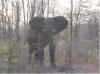
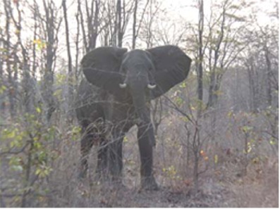
We went for an early game
drive this morning and were rewarded with a couple of large herds of
Sable. After the drive we returned to camp and had breakfast. I swapped
the tire which had been repaired in Lusaka for one of the spares. Later as
we left the park, I sped up to 90kph to check to see if the shudder was
gone. Just as I was feeling happy that it was indeed the tire, I noticed a
police officer ahead waving me to the side of the road. The speed limit
throughout Malawi is 80kph at most and I thought I was in for a fine.
Fortunately he just wanted to see my drivers license, insurance, and
triangles, and was friendly and efficient like all the Malawian police
officers have been so far. We drove for two hours to reach Blantyre in
time for lunch. We dropped the tire off to be balanced and went to a
nearby café for an excellent meal. After lunch we checked into a
backpackers and spent the remainder of the afternoon working on the
website. |
|
|
|
Updated Information
|
Date |
Camp Site or Accommodations |
GPS |
Distance Today:
102km |
Meals
Chicken Soup |
Weather |
|
Near Mt. Mulanue, Malawi |
26 September, 2004 |
CCAP Mission Guesthouse |
15°56.290’S
x 35°30.195’E |
Odometer: 37909km |
Sunny, 98(F) Degrees |
|
Our “campsite” at Doogles
wasn’t actually in the bar, but it might as well have been. The world’s
worst DJ spun the same three or four tracks over and over again, sometimes
stopping halfway through a song, just long enough to think, “Ahh, it’s
over, I can sleep!” Then UB40 would launch into “Red red wine” for the
10th time. We didn’t get a great night’s sleep. In the morning we planned
routes and meals on Mt Mulanje during breakfast. Next we headed to
shoprite to stock up on food for the hike. The drive to the mountain took
us through some nice rolling hills covered with deep greet tea bushes. We
left the tarmac at the town of chitipale with the Mulanje massif rising
impressively to the south. We drove about twenty minutes to the Likhubula
Forestry station. Guides are recommended for the hike, and as we are
planning a five day trip we want a porter to help carry the food. There
are more guides and porters than there are tourists, so to the office has
set up a rotation system to ensure that everyone gets an equal shot at
employment. We were assigned Comestar (guide) and Redson (porter) and
planned to meet them to start the trek tomorrow morning. There are huts on
the mountain, so we won’t bring a tent. The hut fees are $5 per person per
night. Our guide is $6 per day and our porter is $5 per day. After
organizing everything, we went to a nearby mission to camp. There were
lots of people about wanting to do various chores for us to earn some
money. We paid one guy to do some laundry and another to go and get us
beers and sodas while we sorted out our food for the hike. We were
entertained by the mission choir practicing on the verandah as the sun
set. |
|
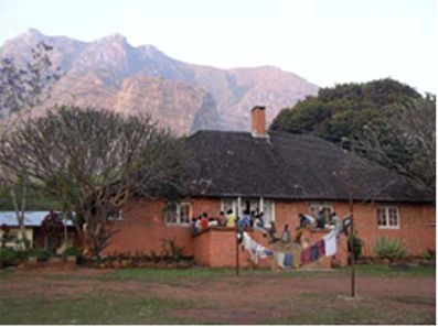
The mission choir. Mt Mulanje
in the background |
|
Updated Information
|
Date |
Camp Site or Accommodations |
GPS |
Distance Today:
7km |
Meals
Pasta with tomatoes and green pepper |
Weather |
|
Mt. Mulanje, Malawi
Witt & Jen |
27 September, 2004 |
Chambe hut |
15°54.495’S x 35°32.596’E |
Odometer: 37916km |
Sunny, 90(F)
degrees |
|
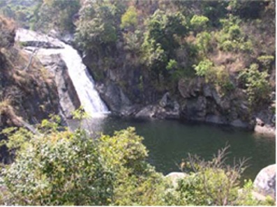
We set off this morning at
about 830. We stopped at a waterfall for abreak and a quick swim, which
felt refreshing after a hot climb. We continued to follow a stream up a
steep valley through some beautiful scenery. We reached the hut at about
230. It is very basic, but clean. It sleeps 16, but Jen and I had the
place to ourselves. We spent the afternoon relaxing on the verandah and
enjoying the views of Chambe peak. In the evening the hut caretaker lit a
fire for us, and the smell of burning cedar filled the air. We cooked
dinner and after Comestar tried to teach Witt how to play bawo (a board
game popular throughout southern Africa) we laid out our sleeping bags on
the floor in front of the fire and drifted off to sleep. |
|
|
|
Updated Information
|
Date |
Camp Site or Accommodations |
GPS |
Distance Today:
6km |
Meals
Cheese and rice casserole |
Weather |
Mt. Mulanje, Malawi
Witt & Jen |
28 September, 2004 |
Cheisepo hut |
15°56.090’S
x 35°35.008’E |
Odometer:
37922km |
Partly cloudy, windy, 85(F) Degrees |
|
After the sort of sleep you
only get after a day of hard physical exercise, we awoke to a beautiful
sunny morning, with the dawn light illuminating the face of Chambe peak.
After breakfast we set off for Chiesepo hut, a new hut at the base of
Sipikwa mountain. Sipikwa is the highest point on the plateau. The plan is
to have a short day today, then climb the peak tomorrow morning and go on
to Thuchila hut in the afternoon. We arrived at Cheisepo by lunch time.
After lunch we found a small pool in a nearby stream that was perfect for
a bath. The water was cold, but the surrounding rock was warm and the sun
helped dry us off. We spent most of the afternoon talking and reading
while the creek babbled in the background, the occasional odor of cedar
smoke drifting down from the hut. Julia and Richard, on holiday from Cape
Town, arrived at about 430 and after dinner the four of us sat around the
fire talking. Their trip is fully catered, and they were kind enough to
share their desert with us, as they were apparently being fed far too
much. The wind picked up later in the evening and clouds began billowing
over the mountain, their wispy tendrils flirting with the light of the
full moon. |
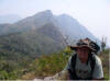
Comstar, Jen, Witt, and Redson. Chambe peak in the background

Comstar, Jen, Witt, and Redson. Chambe peak in the background
|
|
September 29.... |