|
Updated Information
|
Date |
Camp Site or Accommodations |
GPS |
Distance Today:
6km |
Meals
Tuna Curry |
Weather |
Mt. Mulanje, Malawi
Witt & Jen |
29 September, 2004 |
Thuchila Hut |
Not Recorded |
Odometer: 37928km |
Misty, 72(F)
degrees |
|
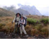
The wind blew all night last
night, causing an annoying squeaking from the tin roof, until the rain
apparently lubricated it enough that it stopped. We awoke to a heavy mist,
an apparently common occurrence here. The rock on the mountain get
slippery when it’s wet, and Comestar recommended we not attempt to climb.
We sat around the fire in the hut with Julia and Richard, drinking hot
chocolate and talking. At around 11am the weather had cleared a little and
we set off for Thuchila hut. The rains had caused the creeks to swell, and
we had to take off our shoes to wade through one of them. We arrived at
Thuchila hut at about 230 and by then the skies were partially clear, with
billowing white clouds playing about the nearby peaks. We walked out to a
viewpoint with Comestar to watch the sunset over Chambe peak. That night
we could see the lights from brush fires on the plains below. Just as we
drifted off to sleep we head a rustling in our food bags, that turned out
to be mice. We hung our food from hooks on the wall, and were able to get
back to sleep. |
Thuchila hut in the midst

|
|
Updated Information
|
Date |
Camp Site or Accommodations |
GPS |
Distance Today:
7km |
Meals
Salmon Curry |
Weather |
|
Near Mt. Mulanue, Malawi |
30 September, 2004 |
Minunu hut |
Not Recorded |
Odometer: 37935km |
Misy, Foggy 70(F) Degrees |
|
Witt and Comestar this morning
set off early to climb Nandalanda peak above the hut. The peak is 2500m
and was very steep. The views from the top were superb, as yesterday’s
rains had cleared the smoke haze from the air. As we descended back to the
hut we dropped into the clouds which enveloped us in mist. We set off for
our next hut, Minunu hut, and walked all day in the clouds. This hut is
much smaller, sleeping only two. There were two local guys there who were
employed catching butterflys for a british guy writing a book on the
subject. It was cold and we enjoyed the warmth of the fire as we ate by
candle light. |
|
|
|
Updated Information
|
Date |
Camp Site or Accommodations |
GPS |
Distance Today:
25km |
Meals
Pasta |
Weather |
|
Near Mt. Mulanje, Malawi
Witt & Jen |
30 September, 2004 |
Lukubala Forest Guesthouse |
Not Recorded |
Odometer: 37934km |
Sunny, 92(F)
degrees |
|
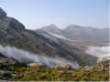
Anticipating a long day,
Comestar had us set off by six am. Fortunately the skies were clear and we
enjoyed beautiful views as we started down the Ruo river valley, which
apparently receives much more rain than the rest of the mountain. The
climb down was steep. Comestar had a stick he was using to beat the
underbrush in front of him. I asked if he was trying to scare away the
snakes. He smiled and thought for a second, then he said he was knocking
moisture off the plants. Good story. We saw three troops of monkeys on the
way down and a couple of Livingstone’s Louries, along with a large
waterfall. It was 1030 when we reached a hydroelectric station which
supplies power to Malawi’s largest tea plantation at the base of the
mountain. Comestar radioed the plantation head office to ask for someone
to come up and give us a lift, but no one was there who could authorize
it, so we set off on foot. We walked for two hours through vivid green tea
fields with purple jacarandas providing contrast. Employees with baskets
on their backs were busily picking tea. The scenery was stunning and Witt
fell behind as he stopped to snap photos. At noon we arrived at the estate
head office, where I accompanied Comestar in to ask for a lift out to the
main road. Apparently the request was given more credence if a white man
was involved. There was still no ride available, and as the walk to the
road was a further 2-3 hours, we sat in the shade to wait. Eventually an
estate security guard volunteered to give us a lift. At the tarmac road we
boarded a minibus that took us at death defying speed to Mulanje town.
There we changed some money at the bank and paid Comestar and Redson. From
there we boarded a larger (and slower) bus that took us a short distance
to Chitapale. We sat on a log in Chitapale waiting for a Mtola (a pickup
truck with a dozen or so people clinging to the back) to take us back to
Likhabula. At 430 we climbed aboard a large commercial truck headed that
way and were finally back at our car at 5pm. A long day indeed, and we
have new appreciation for backpackers who use public transport to get
around. We went to Likhubula Forest Lodge to escape the pestering we
received at the mission. |
Rou falls in the background

|
|
Updated Information
|
Date |
Camp Site or Accommodations |
GPS |
Distance Today:
2km |
Meals
Boxed tuna with pasta |
Weather |
Near Mt. Mulanje, Malawi
Witt & Jen |
01 October, 2004 |
CCAP Mission Guesthouse |
15°56.290’S
x 35°30.195’E |
Odometer:
37936km |
Sunny, 94(F) Degrees |
|
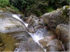
We spent the morning doing
laundry and packing away our backpacking gear. Comestar stopped by and I
gave him a CD containing the photos from our hike. We decided to go back
to the mission as it’s in a prettier area and is cheaper, so we dropped
Comestar off at his house and invited him to dinner later that evening. He
showed up at the mission at about six. We offered him a beer, and it was
apparent that doesn’t drink much, as he was full drunk half way through
it. |
|
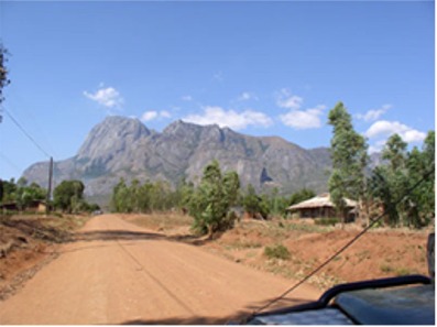
Mt Mulanje. Chambe peak is on
the left |
|
Updated Information
|
Date |
Camp Site or Accommodations |
GPS |
Distance Today:
125km |
Meals
Mexican mince with rice |
Weather |
Blantyre, Malawi
Witt & Jen |
02 October, 2004 |
Kabual Lodge |
15°56.290’S
x 35°30.195’E |
Odometer:
38061km |
Sunny, 94(F) Degrees |
|
We drove back to Blantyre this
morning, having decided to head straight south in Mozambique rather than
do the two-day drive on bad roads to go out to Isle de Mozambique. We
spent the day grocery shopping and checking email, then went to the Kabula
Lodge to camp rather than brave the disco scene at Doogles again. It’s a
decent place with good views over the city. |
|
October 3 >>>>
and Mozambique |