|
Updated Information
|
Date |
Camp Site or Accommodations |
GPS |
Distance Today:
188km |
Meals
PB&J Frisbees, pasta and garlic bread |
Weather |
|
On the piste between
Nouâdibou and Choûm, Mauritania |
21 February
2004 |
Bush Camp |
21°16.653’N
16°23.210’W |
Odometer:
7189 km |
Sunny & 80(F) degrees |
|
We
left the campsite this morning at about 8am and drove the 15km back to the
gas station we stopped at last night for some coffee, croissants, and
orange juice. If the inexpensive fresh squeezed OJ is a Moroccan
phenomenon, we will miss it! We drove for about an hour and arrived at the
border. First was the exit from the Moroccan side, which was fairly
straightforward. The pavement ended at this point and we were now in the
8km section in between countries which is reputed to be mined. We followed
the track for a short distance and met a man sent by Artouro to be our
guide. We followed him along the dirt track to the Mauritanian border. The
contrast between the Moroccan border facilities and those of Mauritania is
remarkable. The Moroccans have basic concrete shelters, whereas the
Mauritanian facilities might as well be a camel herder’s shack, with low
ceilings and tarps for walls. First we stopped at the police checkpoint,
where our details were copied onto a piece of paper. We paid 10 Euros as a
tax on our vehicles. Next it was on to customs, where we declared the
foreign currency we were bringing into the country. The last stop was
immigration where our passports were stamped along with our Carnet du
Passage. We were again charged 10 Euros, which in retrospect I believe was
bogus. In any case, we made it through the border formalities in about 2
hours, far less than what we’d expected. Next it was time to pay our guide
and be on our way. According to Artouro, the standard fee was 200 Ouguiya
(there are about 267 Ouguiyas to the dollar). The guide first demanded we
pay 200 Euros. Graham, who was unfortunate enough to be the one
negotiating, told him that we’d pay 200 Ouguiya and negotiated a deal
whereby he changed 100 Dirham for 2000 Ougs, resulting in a profit of
about 500 Ougs for the guide. He still demanded 30 Euros, so we drove off.
They followed us for awhile, trying to get us to stop, but then they
finally gave up. We soon crossed the railroad tracks and turned east. The
railroad primarily serves the ore mines inland, and the ore trains are
reputedly the longest in the world. Our route will take us about 450 km
inland, following the railroad tracks all the way. The Japanese are
working on building a sealed road, but we’re following a dirt track that
meanders along next to the tracks, crossing sections of sand and rock to
keep the driving interesting. Jen and Witt got another flat, so we stopped
early and found a nice campsite. Graham helped Witt fix the tire, and we
made a meal of pasta with a sauce made from fresh tomatoes and garlic
bread. There is no moon tonight and stars are amazing. Graham built a fire
and we spent a very relaxing evening sitting around the campfire talking
and stargazing. |
We saw lots of camels today

|
|
Updated Information
|
Date |
Camp Site or Accommodations |
GPS |
Distance Today:
162 km |
Meals
Frisbee with sardines, cheese and Pork
Potjie |
Weather |
|
On the piste between
Nouâdibou and Choûm, Mauritania |
22 February
2004 |
Bush Camp |
21°07.796’N
14°05.645’W |
Odometer: 7351 |
Sunny & 80(F) degrees |
|
Waking up in the desert is a great experience.
Those of you who have done it will know. Those of you who have not,
should. We broke camp and headed out early still following the ore railway
towards Choum. The terrain was very varied and we were surprised at the
amount of green grass in some areas. Mauritania is one of the most
sparsely populated countries in Africa, and this was evident in the few,
very small villages that we passed.
The driving was great fun, and Witt did
manage to get Rafiki stuck in some soft sand. A quick tug and he was out,
though. We stopped fairly early close to a small mountain to prepare a
good meal and relax. Connie and Graham cooked a pork potjie, a South
African recipe which turned out pretty well. About the time of dinner,
Witt discovered that Rafiki’s tire rack was pulling free of the back door,
having broken two of the bolts. He and Graham spent a few hours pulling
the old parts off and finding new bolts and washers to try to repair the
damage and make it stronger. We all had a good time after dinner enjoying
the fire and the stars. |
Lots of local Land Rovers in Mauritania
‘Miles and Miles of Bloody Africa’
Refueling on the piste using a Super Siphon donated by Pangaea Expeditions!

Lots of local Land Rovers in Mauritania
|
|
Updated Information
|
Date |
Camp Site or Accommodations |
GPS |
Distance Today:
124 km |
Meals
Salami, yogurt, Frisbees and chicken
tikka masala |
Weather |
|
Atâr, Mauritania |
23 February
2004 |
Bab Sahara |
20°31.165’N
13°03.721’W |
Odometer: 7475 |
Sunny & 102(F) degrees
|
|
After getting up, we finished fixing the tire
carrier on Rafiki. Witt also did a check under the car and made sure
everything was tight. We carried on the piste, much as yesterday. When we
got close to Choûm, we turned southeast and made our own track towards
Atâr hoping to pick up the road. We did reach the road eventually and
followed that into Atâr. For the last 15 miles we were privileged enough
to use a brand new asphalt road provided by the US government. Of course
this meant we had to stop and air up our tires. After getting into Atâr,
we made our way to Bab Sahara, a campground run by a Dutch couple. They
are smart enough to put their GPS coordinates on their business card, so
it is easy to find. Despite being in the middle of Atâr, the campsite is
clean and well maintained with showers and some of the nicest toilets we
have experienced yet. Graham spent the evening wrestling with a flat tire
while Witt cooked dinner that we ate on the verandah at Bab Sahara. |
The original Land Rover came in herds

|
|
Updated Information
|
Date |
Camp Site or Accommodations |
GPS |
Distance Today:
124km |
Meals
PB & J Frisbees, charred meat and chips |
Weather |
|
Atâr, Mauritania |
24 February
2004 |
Bab Sahara |
20°31.165’N
13°03.721’W |
Odometer: 7475km |
Sunny & 95(F) degrees
|
|
We were relieved to learn that Jus, the Dutch
owner of the campground, can arrange visa extensions for us, which means
that we won’t have to rush to Nuokchott today. Graham worked on his car
while Jen and Connie did laundry and Witt played with the computer. The
campground is very nice, with a shady veranda, sinks with soap, and
toilets with toilet paper! In the afternoon we walked into town to use the
internet. It’s easy to see that Mauritania is much less developed than
Morocco. We were hassled by people trying to sell us trinkets and get us
to visit their shops on the way back to the campground. We had arranged to
have dinner at the campground restaurant at eight PM. The dinner consisted
of some charred bits of meat and overcooked French fries, leaving us quite
disappointed. We met an older German guy who works for a firm that digs
water wells. He has been to 30 African countries and must have some
amazing stories to tell. We’re planning to head for Chinguetti tomorrow. |
|
Updated Information
|
Date |
Camp Site or Accommodations |
GPS |
Distance Today:
99km |
Meals
Freshly baked bread, scrambled eggs with
veggies |
Weather |
|
Near Chinguetti,
Mauritania |
25 February
2004 |
Bush Camp |
20°32.717’N
12°13.232’W |
Odometer: 7574km |
Partly Cloudy & 90(F) degrees
|
|
After an unsuccessful attempt
this morning to send our website updates, we left for Chinguetti, which is
supposed to be the seventh holiest city in Islam, and was once home to
Islamic scholars. The piste out of Atar started out corrugated, then we
hit a section of new but rapidly crumbling tarmac as we climbed onto the
plateau. At the top the road returned to dirt, but it was freshly graded
and fast for 40km. After we passed the road crew it became evident why the
grading was needed. We arrived in Chinguetti shortly thereafter, and
looked for somewhere to have lunch. We didn’t find anything and were
rather disappointed with the town, so we headed out into the sand dunes to
camp for the evening. We drove down (or up, I don’t know which way the
water flows) an oued or river bed along the route to Ouedane. Witt got
stuck once again (he forgot to engage the differential lock) and Graham’s
winch acquitted itself well in extracting him. Three local women and a
couple of kids approached during the recovery. Jen tried to speak to them
in French, but the conversations quickly degraded into requests for gifts.
We soon stopped and made camp. Graham took off his desert driving hat and
put on his pastry chef’s hat and made a loaf of bread to be baked over the
fire in the dutch oven. Strangely, the bread came out looking almost
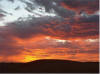
identical to a Moroccan Frisbee. We watched few camels and a camel herder
on the horizon through binoculars then enjoyed a beautiful sunset. We had
Graham’s bread with dinner, and were treated to another night of excellent
star gazing. During dinner our fluorescent adventure light attracted a
small swarm of grasshoppers (not more locusts!). Graham had the bright
idea to move the light near the fire. We enjoyed watching the little
buggers leap into the flames. Sweet revenge. |
Graham deploying the winch cable Jen scoping out the camels

Graham deploying the winch cable
|
|
Updated Information
|
Date |
Camp Site or Accommodations |
GPS |
Distance Today:
297km |
Meals
Stir fry with onions, carrots, and
eggplant |
Weather |
|
Between Atar & Nouakchott, Mauritania |
26 February
2004 |
Bush Camp |
19°57.479’N
13°58.640’W |
Odometer: 7772km |
Sunny & 95(F) degrees |
|
We left Chinguetti this
morning after a delicious apricot scone, also baked by Graham. He’s
talking about trading his Land Rover in for a bakery in Louisville (not
really). We stopped in Atar for fuel, and headed toward a piste described
by Chris Scott which ends at a Guelta, or the end of a canyon with palm
trees and in this case a swimming hole. Unfortunately we weren’t able to
find the correct road and ended out heading down the main road toward
Nouakchott, where we will get our visas for Mali. The road is newly
surfaced, financed by the Japanese. In some places it is already crumbling
at the edges, and one section has been washed out by a storm. We were able
to make good time despite a camel sitting in the middle of the road and
various animals and people crossing the road in front of us at various
times. |
|
|
|
More of Mauratania |